Posts

Showing posts from March, 2010

New Zealand: Milford Track Day 3

Image
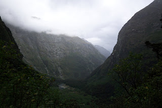
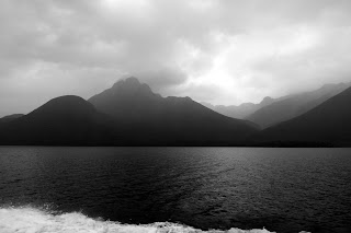
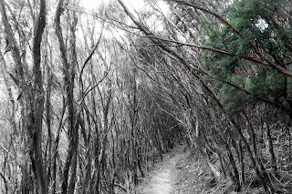
After a brief absence (due to the fact that I left my camera on the bus from Milford to Te Anau and had to wait for them to ship it back to me), we now continue with:  Day 3 Woke up, out the door by 8. Hut mgr says we're in for a bit of weather. About 20 mins down the track we begin the ascent up the mntn and that's when it starts to rain. It doesn't stop raining for 12 hours. Reaching the summit isn't too challenging, but it's cold, windy and raining hard. The mntn is steeped in fog so visibility is nil. It's a bit disappointing. We can see bits and pieces looking back at Clinton Valley, but nothing on the other side. At the peak of Mt. McKinnon, when we cross over to the other side (towards the ocean), we're now entering literally one of the wettest places on earth. We descend from 1045 meters over the next several hours. Seeing the rainforest dripping wet is kinda cool. We get below the fog and reach the hiker shelter for some instant

New Zealand Milford Track Day 2

Image
Day 2 Woke up at 7, sun still not up. Deep In a valley stays dark til late. On the track by 8, fairly cold. Soon we're at where the Clinton valley widens, following the river. Huge cliff walls on either side, waterfalls.  by this point we've see literally 50 or 60 waterfalls The rainforest is filled with exotic birds, plants, mushrooms; it's like being in the land before time, like a brontosaurus could stroll past at any moment. Something magical around every turn. 16.5k later arrived at the minotua hut. Some hikers go on to the top and back just in case the weather obscures it tomorrow. It's supposed to rain, but were just too tired to attempt it today. We lounge around the hut, aching. Tomorrow is the big day, the one everyone warns us about as the biggest challenge and greatest reward: mckinnon pass. Unfortunately, I left my camera on the bus on the way out of day 4, which had the memory card with my pics of days 3 and 4. They found

something i'll miss about Melbourne

Image
you can't get it like this in Starbucks-infested America

New Zealand: Milford Track Day 1

Image
7 am Bus to te anaua then bus to te anau downs then ferry across lake te anau. It's raining so can't see much as we cross the lake. It's only an hour hike to our first shelter, Clinton Hut, and thank god cuz we were soaking wet. March is the driest month of the year, but southwest New Zealand is still one of the wettest places in the world. Set up in our bunk beds, try to dry out our gear. Rain cleared up at about 4. Clinton hut is in a valley surrounded by rainforest and jagged rock peaks that have no foothills. Just massive spires straight up. Guided nature walk with ranger Russ to explain some of the flora and fauna of the area, then glow worm spotting after dark: like miniature stars. So far we haven't seen or done much, but Day 2 is when things start to get interesting. More posts coming soon.

New Zealand: Milford Track Day 0

Image
Fly Melbourne to Christchurch to Queenstown . this is the first thing we saw of the south island: when i was in Taupo (pronounced either Taw-Poh or Toe-Paw, depending on if you're a Kiwi or Maori), NZ (on the north island), a local told me that the south island's scenery was much more "dramatic". Now i know what she meant.   The air new Zealand safety video had actors as flight attendants wearing body paint uniforms. "air new Zealand - we've nothing to hide". Weird. Queenstown is on the edge of lake Te Anau (pronounced Tee-Ahh-Now) It's so beautiful I can't believe it. We could have spent days here just exploring the area around the town. Huge rocky mountains like CO. Tourist town like beaver creek or vail. Tshirt shops everywhere, lots of American accents. Our hotel is right on the edge of the water. The next day we start our 4 day backpack trip across the 53k Milford Track in Fiodland National Park . I'll post the first

Wilsons Promontory, Part 2

Image
sealers cove is apparently one of the can't-miss sights of the prom. it took 10ks of hiking to get there   through a trail that looked straight out of a grimm brothers fairy tale the cove itself was secluded, pristine, surrounded by green hilly coastline, a lot like tasmania after the return trip, we were all a bit tired (i hadn't hiked 20ks [12 miles] in a single day in a few years) but we stopped off at the incredible Whisky beach right next door to squeaky beach, it had that same beautiful white sand, clear blue water and rocky areas thumb rock. get it? the next day, on the way back we stopped off at a petting zoo to give our guest Nan a close up view of some Aussie wildlife. check this albino roo (in Aussie, that's pronounced al-bee-no) and, the obligatory koalas dirty, filthy creatures

Wilson's Promontory, Part 1

Image
last weekend, took the 3 hour drive down to the south of Victoria (through the area known as 'Gippsland') to Wilson's Promontory National Park, known to the locals as the Prom. It's a stretch of coastline at the southernmost point of mainland Australia. It's a trip to look out over the southern ocean and know the only thing between you and icy Antarctica is a little hunk of land known as Tasmania.   whisky beach      the tidal river flowing into the ocean     more tidal river      alpacas at the cabin we stayed in near Yanakie, VIC      leftovers from 2005 brushfire. when we were in the Grampians a few months ago, saw a quote from an aboriginal leader: "white man fear the fire. they rush to put it out, but don't realize it is needed for new life". I'm paraphrasing, but it's an interesting take on something so destructive.   rainforest trail taking us to Sealers Cove... to be continued